About LinkingAlps
Travelling across the Alps should be simple. Whether you are commuting across borders, exploring new regions, or planning a holiday in one of Europe’s most iconic landscapes, you expect your journey to be smooth, reliable, and easy to plan. Yet travellers often face a familiar problem: information stops at borders.
A trip that begins in one country and continues into another often requires switching between several journey planners; each with its own maps, timetables, and levels of detail. Connections that seem obvious in real life remain hidden in digital tools. Real-time updates differ, data formats are inconsistent, and the overall picture of your journey remains fragmented.
LinkingAlps was created to change that.
LinkingAlps connects existing journey planners across the Alpine region into a single, interoperable network. Instead of building a new platform or central database, it links the systems that already know their regions best. This means travellers can receive accurate, local, multimodal information for their entire cross-border journey, directly from the authoritative sources behind each part of the route.
The LinkingAlps service currently spans across five regions/countries -Austria, Slovenia, Switzerland, South Tyrol and Lombardy- bringing together their national, regional, or local journey planners into one seamless network.
The LinkingAlps Story
The LinkingAlps story began in 2019 with the Interreg Alpine Space Program LinkingAlps. It brought together a group of 14 partners, including government authorities, public transport authorities, and travel information experts from Austria, Germany, Italy, Slovenia, Switzerland, and France, who all had the same thought at some point: “Why is planning a trip across the Alps still so complicated?” Instead of creating yet another journey planner, the partners decided to connect the ones that already exist, to help people to get from A to B without making them open five different apps.
LinkingAlps focused on:
- Getting journey planners from different countries to “talk” to each other.
- Making sure travellers get one complete route instead of a puzzle with missing pieces.
- Encouraging more people to use buses, trains, and other eco-friendly options.
- Making life easier for tourists, commuters, and anyone who’s just trying to get around without stress.
Legislative Framework
The Legislative Framework behind LinkingAlps ensures that travel information can flow smoothly across borders. To make this possible, the European Union established rules that help countries share mobility data in a compatible and coordinated way.
The core idea is simple: all journey planners in Europe should be able to exchange information using the same basic principles. This prevents each country from developing its own isolated system and ensures that cross-border travel information becomes as seamless as possible. A key EU regulation, the Delegated Regulation (EU) 2017/1926, requires countries to make their public transport data accessible in standardised formats and to enable journey planners and multimodal travel information services to exchange routing results with one another. This regulation defines the technical specifications for providing multimodal travel information services, ensuring interoperability across borders.
Thanks to these shared rules and standards, LinkingAlps can connect multiple national and regional systems into one coherent information network, allowing travel information to continue smoothly where national boundaries end.
How does it work?
The technical idea behind LinkingAlps may sound complex, but the concept is surprisingly straightforward: make different journey planners work together without forcing them into one giant system.
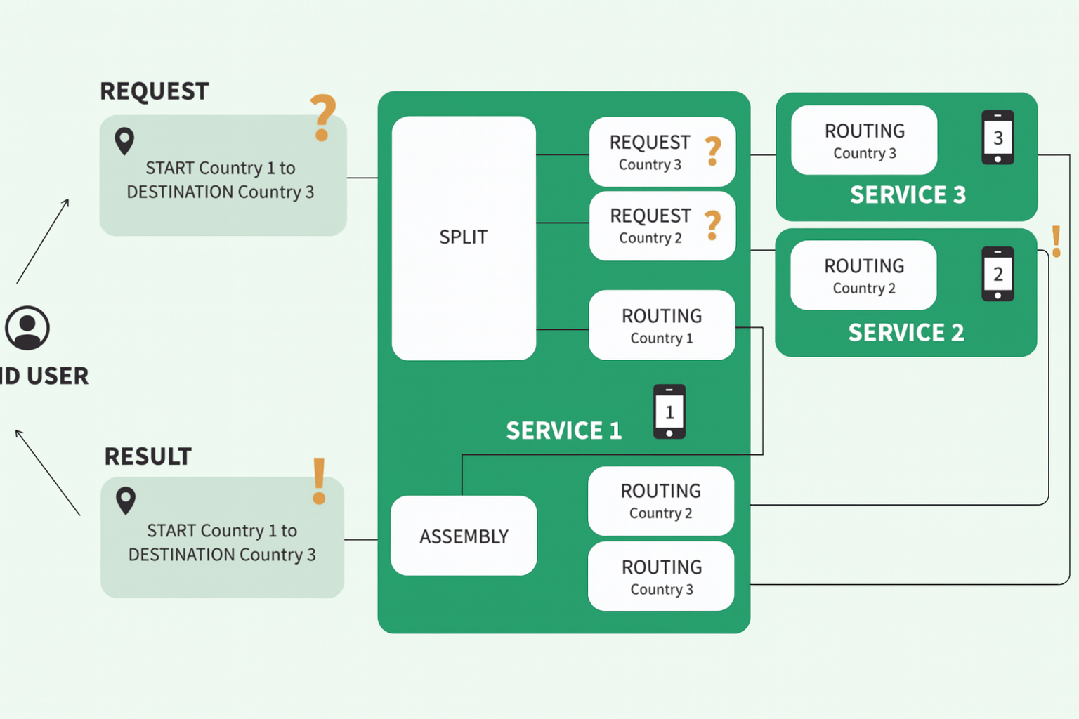
Instead of copying all data into one place (which is messy, expensive, and nobody likes giving up control), LinkingAlps uses a clever method: the planners simply ask each other for help when a route goes beyond their borders.
This is possible because they all use the same technical language called OJP (Open API for Distributed Journey Planning).
- Your journey planner checks what it knows.
- For the parts outside its area, it sends a request to the journey planner responsible for that region.
- Each planner sends back the part it knows best.
- Your planner stitches everything together into one clean route.
Why is this smart?
- Everyone keeps control of their own data.
- Information is always accurate and up to date.
- New regions can join easily.
- Travellers get one seamless route instead of fragmented pieces.